Posts

Showing posts with the label GPS

Google Ads

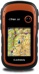
Do it yourself Garmin eTrex 20 carabiner clip

Image
From this part of the world (Malaysia), a carabiner clip costs me at about RM50. I felt that it was a bit expensive for a simple accessory to invest in. By using a cheap made in China normal carabiner clip (i got it from ACE hardware at Queensbay Mall) with 2 small cable ties, i am able to make my own Garmin eTrex20 carabinar clip. Below are my snapshots of my poor man Garmin eTrex20 carabiner clip.
Free routable maps for Garmin brand GPS devices

Image
This website provides free Garmin routable maps of the world. Select your desired map region and direct download the IMG file. The maps are generated from OpenStreetMap.

OSM Map On Garmin

Image
A comprehensive guide on how to manually convert OpenStreetMaps to Garmin IMG map format with different methods.

Free Garmin maps of the world

Image
A comprehensive list of websites to download free Garmin maps of the world generated by OpenStreetMaps.

GPS Tracklog : Garmin eTrex 20 review

Image
This is a very good review on Garmin eTrek 20 that really covers every aspect of the GPS device. This is definitely a recommended read before you buy this.

How to create Garmin custom map using MobAC

Image
This is a good step by step instructions on how you can create a Garmin custom map using MobAC written by thebikegeek.blogspot.com . Garmin custom map is a feature where you can use a normal JPEG image map captured from camera or scanned paper map as the map overlay on your Garmin devices.

Garmin eTrex Tips

Image
A good collection of tips and tricks for Garmin eTrex GPS unit. This is a must read website before you start to use your etrex unit.

Garmin eTrex 20 manuals

Image
A list of eTrex 20 user manuals for downloads.

How to get free topographic map into Garmin eTrex 20

Image
This post will guide you on how to download the SRTM3 data to create a topographic contour map to complement your existing Garmin street maps in your Garmin eTrex 20 GPS device. You will use it like an extra layer of map on top of your existing Garmin street map. If you have not got a street map and you are interested in getting the street map for your Garmin eTrex 20 device, please refer to  How to get free routable maps into Garmin eTrex 20 .  If you are interested to get street maps for Malaysia and Singapore, please refer to  How to install malfreemaps into Garmin eTrex 20 . Malfreemaps provides a very comprehensive map of Malaysia and Singapore, more comprehensive map than the free OpenStreetMaps. Note: The steps below only applicable for Windows OS and make sure you have Java installed into your system.

How to get free routable maps into Garmin eTrex 20

Image
This post will guide you how to get routable OpenStreetMap(OSM) maps into your Garmin eTrex 20 GPS unit. OSM maps are not comprehensive compare to other Garmin maps that you can purchase from Garmin but never the less they are free and you have the whole world to select for download. Note: I have tested this on my Garmin eTrex 20 and i am sure that this method also works for Garmin eTrex 30 units as well.

How to install malfreemaps into Garmin eTrex 20

Image
Malaysia and ASEAN Free Maps Project Forum (malfreemaps) provides a very comprehensive free Garmin map of Malaysia and Singapore for Garmin GPS devices. Malfreemaps works perfectly well on Garmin eTrex 20. I am sure this also applies on the Garmin eTrex 30 unit as well.

How to add OSM Cycle Map as custom map source to MOBAC

A reference of how to add Open Cycle Map (topo map) into MOBAC as a custom map source. Maps downloaded can be use as offline maps for supported applications in MOBAC.

GPX Editor

Image
This is a nifty piece of software that enables you to edit your GPX track logs. It's light, standalone and very easy to use for editing your GPX track log file.  I used Sports Tracker or ViewRanger to track my hiking trails and usually the track logs will have some erratic points due to stationary position and some spikes due to inaccuracy of the GPS reading. Using GPX Editor enables me to clean up the tracks pretty fast and efficiently. This software is still under rapid development and expect some hiccups from the software but overall it's usable for my needs. Unfortunately GPX Editor only runs on Windows platform, however i have tested it to run under Wine for my Ubuntu Linux platform and it runs and performs most of the functions but the map background overlay does not work from the software. You will have to open the html file created at the same folder to view it in your web browser. These are some of the nice features GPX Editor has...

Difference between a KML and a KMZ file

A KML file is a "flat" file or text based file composed of Tags similar to XML or HTML. A KMZ file is basically a ZIP archive that contains a KML file. This was done so that your any software such as Google Earth would automatically recognize it as a file and open it. If they had left it as a .ZIP file, then it wouldn't automatically open the file.